|
Bearings |
|
|
|
To use the resources of this chapter you must first register |
|
|
CONTENTS |
|
|
ITEM |
|
TYPE |
|
NUMBER |
|
| Working with maps and angles |
|
Workout |
|
40 slides |
|
| Angles and bearings |
|
Library |
|
10 questions |
|
|
|
Once you have registered, you can work through the slides one by one.
The workout comprises a series of sides that guide you systematically through the topic concept by concept, skill by skill. The slides may be used with or without the support of a tutor. The methodology is based on problem-solving that advances in logical succession by concept and difficulty. The student is presented with a problem or series of questions, and the next slide presents the fully-worked solution. To use the material you must sign-in or create an account.
blacksacademy.net comprises a complete course in mathematics with resources that are comprehensive.
|
|
|
|
SAMPLE FROM THE WORKOUT |
| Showing American English version |
SLIDE 1 - QUESTION 1 |
 |
|
SLIDE 2 - SOLUTION |
 |
|
|
SAMPLE FROM THE LIBRARY |
| Showing American English version |
QUESTION [difficulty 0.1] |
 |
|
SOLUTION |
 |
|
|
DEPENDENCIES |
|
|
|
|
CONCEPTS |
|
|
|
|
LEV. |
|
|
Compass points, North, South, West, East
|
|
472.1 |
|
|
Sunrise - east, sunset - west
|
|
472.1 |
|
|
Sphere
|
|
472.3 |
|
|
Earth is a sphere
|
|
472.3 |
|
|
Geographical coordinate system
|
|
472.3 |
|
|
Latitude and longitude
|
|
472.3 |
|
|
Southern and northern sky / hemisphere
|
|
472.5 |
|
|
Orientation by position of sun (implicit)
|
|
472.6 |
|
|
Zenith
|
|
472.7 |
|
|
Standard time, summer time
|
|
472.7 |
|
|
Summer / winter solstice
|
|
472.8 |
|
|
Spring (vernal) / autumn equinox
|
|
472.9 |
|
|
Parallel, meridian, North / South pole
|
|
473.0 |
|
|
Stereographic project (implicit)
|
|
473.1 |
|
|
Map as a projection
|
|
473.6 |
|
|
Mercator projection
|
|
473.6 |
|
|
Geographical coordinates
|
|
473.7 |
|
|
Clockwise / anticlockwise
|
|
473.9 |
|
|
Geometric coordinates from positive x-axis
|
|
473.9 |
|
|
Bearing
|
|
474.2 |
|
|
Intersection of bearings
|
|
474.7 |
|
|
Magnet, North and South poles
|
|
475.1 |
|
|
Magnetic monopole (impossible)
|
|
475.3 |
|
|
Ferromagnetism
|
|
475.3 |
|
|
Earth as a magnet owing to liquid core
|
|
475.6 |
|
|
North magnetic pole
|
|
475.7 |
|
|
Magnetic compass
|
|
475.8 |
|
|
Orienteering
|
|
475.8 |
|
|
Magnetic declination
|
|
475.8 |
|
|
|
|
RAW CONTENT OF THE WORKOUT |
|
| To make use of this chapter, please first register. Then you can work through the slides one by one. |
|
| What is provided here is the raw text of the workout. Most of the information is contained in the image files, which are not included with this text. The text may appear deceptively short. (The content overall of blacksacademy.net is vast.) Any in-line questions appear as a question mark [?]. This text is provided only as an indication of the overall quantity of material contained in the chapter. To use the material you must sign-in or create an account. |
|
| * |
|
|
SLIDE 1
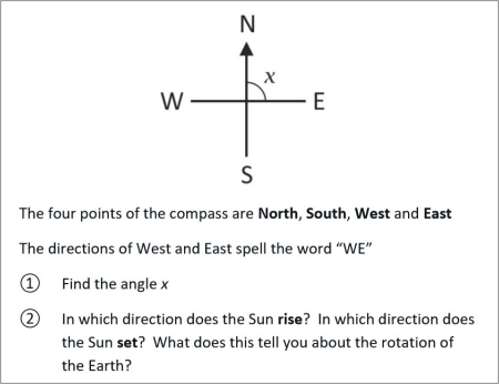
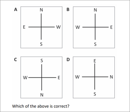
The four points of the compass are North, South, West and East
The directions of West and East spell the word “WE”
? Find the angle x
? In which direction does the Sun rise? In which direction does the Sun set? What does this tell you about the rotation of the Earth?
SLIDE 2
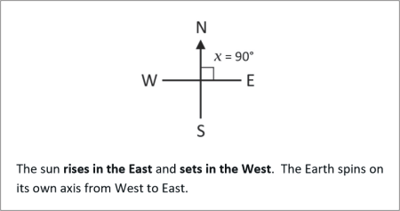
The sun rises in the East and sets in the West. The Earth spins on its own axis from West to East.
SLIDE 3
Image: https://commons.wikimedia.org/wiki/File:Azimutalprojektion-schief_kl.jpg
The Earth is a sphere.
The geographic coordinate system represents positions on the surface of this sphere using lines of latitude and longitude.
Latitudes run from East to West. Longitudes run from North to South.
SLIDE 4
The geographic coordinate system represents positions on the surface of this sphere using lines of latitude and longitude
The latitude running around the middle of the globe dividing it into two hemispheres is called the equator.
? Make a sketch of the globe showing the northern and southern hemispheres.
? You are in the Northern hemisphere in open space and it is morning. How can you tell from the position of the Sun in the sky roughly in which direction you are facing? How would this be different if you were in the Southern hemisphere?
SLIDE 5
In the Northern hemisphere the Sun appears in the southern sky. In the Southern hemisphere this is reversed: the Sun appears in the northern sky.
You are in the northern hemisphere
? You are facing the rising Sun. Where is North?
? Where is North if you are facing the setting Sun?
SLIDE 6
You are in the northern hemisphere.
? You are facing the rising Sun. Where is North?
Answer: The Sun rises in the East, so North is on your left.
? Where is North if you are facing the setting Sun?
Answer: The Sun sets in the West, so North in on your right.
SLIDE 7
The position of the Sun where it is at its highest point is called its zenith. The time of day is midday, noon, 12 pm.
The highest point of the Sun in the sky changes as the Earth rotates around the Sun.
The diagram shows the path of the Sun in March (Spring). Draw onto this diagram two more curves showing the path of the Sun in December (winter) and June (summer)
Notes
In the science of astronomy, the Sun does not have a zenith. We use the word “zenith” in the way it is used in common language, and not in astronomy.
The time at which the Sun reaches its highest point may not be locally noon, because in some countries standard time is adjusted in the summer to summertime by adding one hour to the clock. This means that instead of the Sun reaching its highest point at 12 noon, it reaches its highest point at 1 p.m. This may also vary from location to location because of time zones.
SLIDE 8
For a given location, when the Sun reaches its maximum height in the sky, it is the summer solstice. In the Northern hemisphere the summer solstice occurs on June 21. This is the longest day of the year.
When the sun height at noon is its minimum, it is the winter solstice. In the Northern hemisphere the winter solstice occurs on December 21. This is the shortest day of the year.
? What are the summer and winter solstices in the Southern hemisphere?
? The year is divided into four equal parts – winter begins on the day of the winter solstice. What are the names given to the beginning of spring and autumn and in which months do they occur?
? If the Sun is at its highest point on June 21, why is that only the beginning of summer and not the middle of it?
SLIDE 9
? In the Southern hemisphere the summer solstice is December 21 and the winter solstice is June 21.
? The year is divided into four equal parts – winter begins on the day of the winter solstice. What are the names given to the beginning of spring and autumn?
The Spring equinox, also called the vernal equinox, marks the beginning of spring and occurs in March. The Autumn equinox marks the beginning of autumn and occurs in September. The exact day varies because the year is not exactly 365 days, and there are Leap Years.
? The Sun’s rays heat the Earth. In summer the heating effect builds up during the summer, and the seasons also reflect the response of nature to the sun. Plants start to grow in spring.
Notes
The day that each season is said to start varies from country to country, and some countries, because of their location, for example, being on the equator, do not have four seasons.
SLIDE 10
Lines of latitude are also called parallels. Lines of longitude are also called meridians.
Imagine you are looking down at the Earth from directly above the the North Pole. Draw what you see as you look towards the equator in every direction. Draw all the meridians in increments of 15°. (There are 360° in a circle.)
SLIDE 11
The 0° meridian (longitude) is the line that passes from North to South through Greenwich, London. This is by international agreement.
SLIDE 12
Parallels are fixed by reference to an angle at the centre of the Earth. Parallels towards the North Pole are marked N. Parallels to towards the South Pole are marked S.
You are standing at the North Pole looking towards the equator. Draw what you see and mark
? the 30°N, 60°N parallels
? the 0°, 45°E, 90°E, 135°E, 180°, 45°W, 90°W, 135°W meridians
SLIDE 13
SLIDE 14
If the Earth is really a sphere, why does it appear to be flat?
SLIDE 15
The Earth is really a sphere but appears to be flat to because it is so large in comparison to a human being.
SLIDE 16
It is useful to make a map of the Earth. The spherical shape of the Earth is projected onto a flat surface.
There are several different ways in which the spherical shape of the Earth can be made into a map. This image shows the Mercator projection.
Image author: Strebe
https://commons.wikimedia.org/wiki/File:Mercator_projection_Square.JPG
SLIDE 17
Latitude and longitude form a coordinate system.
From the map find the coordinates to the nearest 0.5° of
? London ? Liverpool ? Edinburgh ? Belfast
SLIDE 18
? London 51.5°N, 0°W ? Liverpool 53.5°N, 3°W
? Edinburgh 56.0°N, 3°W ? Belfast 54.5°N, 6°W
SLIDE 19
Angles can be measured in two directions
clockwise or anticlockwise
In coordinate geometry it is usual to measure angles from the positive x-axis.
SLIDE 20
Use a protractor to measure the above angles to the nearest 1°
SLIDE 21
SLIDE 22
In geography, navigation and map work, angles are measured clockwise from the North direction.
Such an angle is called a bearing
SLIDE 23
Use a protractor to find the above bearings
SLIDE 24
SLIDE 25
Find the bearing
? of Edinburgh from Belfast
? of Liverpool from Edinburgh
? of Liverpool from London
SLIDE26
? The bearing of Edinburg from Belfast is 55°
? The bearing of Liverpool from Edinburgh is 180°
? The bearing of Liverpool from London is 312°
SLIDE 27
Which city lies on the intersection of a bearing of 330° from London and 105° from Belfast? What the latitude and longitude of this location to the nearest 0.5°?
SLIDE 28
Which city lies on the intersection of a bearing of 330° from London and 105° from Belfast? What the latitude and longitude of this location to the nearest 0.5°?
Answer: York, with grid coordinates 54°N, 2°W
SLIDE 29
Which city lies on the intersection of a bearing of 69° from St. David’s and 174° from Edinburgh? What the latitude and longitude of this location to the nearest 0.5°?
SLIDE 30
Which city lies on the intersection of a bearing of 69° from St. David’s and 174° from Edinburgh? What the latitude and longitude of this location to the nearest 0.5°?
Answer: Coventry with grid coordinates 52.5°N, 2.5°W
SLIDE 31
Magnets have North (N) and South (S) poles
Magnets follow the rule that like poles repel, unlike poles attract
Complete the following table
North South
North Repel
South
SLIDE 32
North South
North Repel Attract
South Attract Repel
SLIDE 33
Magnetic poles are not coloured, but we often paint bar magnets so that the North Pole is red and the South Pole is blue.
At the present time, no isolated magnetic pole has been discovered. Any magnet consists of both a North Pole and a South Pole. Effectively, all magnets are bar magnets.
Assuming that all magnetic poles are free to move (no friction), for each the above state whether the arrangements of magnets is possible or impossible.
SLIDE 34
? Possible. North and South poles face each other.
? Impossible. South repels South.
? Impossible. Unlike poles repel, and this arrangement also has two isolated North Poles (monopoles) and this has not been discovered in nature.
? Impossible. South repels South.
? Possible. North and South poles face and touch each other.
? Possible. North and South poles face and touch each other.
SLIDE 35
The strongest natural form of magnetism arises in ferromagnetic metals.
The ferromagnetic metals are iron, cobalt and nickel.
The Earth is a giant magnet. Suggest what might explain why the Earth is a magnet.
SLIDE 36
Image by Kelvinsong
File location: https://commons.wikimedia.org/wiki/File:Earth_poster.svg
The Earth is thought to have an outer core made of liquid iron, which is a magnetic material. The rotation of the Earth causes this liquid to flow. When a magnetic material flows, this gives rise to magnetism.
SLIDE 37
The Earth has a magnetic north pole. This is not located at the precise place of the geographic north pole.
Image source: Wikicommons
? In which direction does the north pole of a magnetic compass point? What is a magnetic compass used for?
? What kind of pole is the North Magnetic Pole? Is it a south pole or a north pole?
? If the North Magnetic Pole is not precisely where the Geographical North Pole is found why doesn’t this make magnitic compasses useless?
SLIDE 38
? In which direction does the north pole of a magnetic compass point? What is a magnetic compass used for?
The north pole of a magnetic compass points towars the North Magnetic Pole. Magnetic compasses are used to find directions, for orientation and for navigation.
? What kind of pole is the North Magnetic Pole? Is it a south pole or a north pole?
The North Magnetic Pole is magnetically a south pole. The north pole of a magnetic compass points towards it.
? If the North Magnetic Pole is not precisely where the Geographical North Pole is found why doesn’t this make magnetic compasses useless?
Accurate maps have a separate arrow pointing in the direction of the Magnetic North Pole. This is called magnetic declination. If you are using a compass to find a direction, you should be able to adjust your compass for this.
SLIDE 39
At the foot of a map you see the diagram to the right
? What is the magnetic declination?
? By how many degrees do you adjust the magnetic compass screw that you find on its back?
? Do you adjust the compass East or West?
SLIDE 40
? the magnetic declination is 8°
? You adjust the screw by 8°
? The declination is to the right. You adjust it 8° East.
|
|

